I find it, um, strange that the coffeehouse music includes a Peter Framptonesque talking guitar version of “Rocket Man.” There’s something very wrong about that.
Go to Coffeehouse Observer for more coffeehouse observations.
I find it, um, strange that the coffeehouse music includes a Peter Framptonesque talking guitar version of “Rocket Man.” There’s something very wrong about that.
Go to Coffeehouse Observer for more coffeehouse observations.
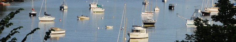
BANGOR, Maine — The crowd began gathering around 4 p.m. to welcome the sixth annual American Folk Festival on the Bangor Waterfront. With full sun, mid-80s temperatures and cloudless skies forecast for the weekend, the biggest party in Bangor was off to a rousing start for the nearly 100,000 people estimated to attend this year.
The Pride of Maine Black Bear Marching Band took formation in West Market Square around 6 p.m. and performed for a crowd of several hundred, some of whom arrived early to snag a seat at one of the downtown eateries. Band director Chris White stood atop a platform and conducted the band through a selection of pop hits and the ubiquitous “Maine Stein Song,” the anthem of the University of Maine.
“I think it’s fantastic,” said Andrew Day, service manager at Paddy Murphy’s Pub, located just off West Market Square. “We had people get here early to watch the parade from inside. It’s definitely been a boon. West Market is the heart of downtown, and there’s nowhere else the festival should start.”
Click for the rest of the story by Emily Burnham in the Bangor Daily News, along with photos and video.
Paying a local price for I-95’s global promise | NPR
This NPR story caught my eye because Interstate 95 is the closest interstate highway to where I grew up in Aroostook County.
State Route 11 was the only paved road in and out of Portage, but as an adult I’ve lived in cities bisected by several interstate, U.S. and state highways.
Route 11 still is the only paved way in and out of Portage and I’m pretty sure no one living there is interested in adding any commuter lanes or interchanges or bypasses. My mother used to lament about the “traffic” on the road when we lived on Route 11 leading into Portage. There were too many logging trucks going too fast for her.
The northern terminus of I-95 is at Houlton, Aroostook County’s county seat and a border crossing into Canada. The oldest and longest of the interstates, I-95 runs from Houlton to southern Florida.
Whenever we wanted to visit points south we would drive south on frost-damaged state Route 11 – also known as the Aroostook Scenic Highway – through Ashland. Farther south we would turn east at Knowles Corner onto state Route 212 to Symrna Mills and onto southbound I-95. Or we would bypassed the Knowles Corner turnoff and continued on Route 11 through to Patten and then to I-95.
I’ve driven a lot of interstate highways in the past 30 or more years and I-95 through Maine’s North Woods must be among the most remote interstates in the continental United States. It was not uncommon to drive from Houlton, Symrna Mills or Patten and not see another vehicle for miles and miles of forest-lined concrete highway. It was difficult sometimes not to nod off just a bit and it is not unusual to come across a moose or black bear standing in the middle of the lanes.

Mount Katahdin
From doorstep to Bangor was about a three-hour drive, with about two-thirds of that on I-95. There is a section that opens up just a bit and allows a scenic view of Mount Katahdin, the highest mountain in Maine and the official end of the Appalachian Trial. (Some believe the Appalachian Mountains actually continue to Mars Hill, Maine, and there was a report earlier this summer that a section of the mountain range was left behind in Europe when the tectonic plates shifted. Also, a few days ago I posted photos of Mount Katahdin taken by a high school classmate, Kelly McInnis. https://lettersfromaway.wordpress.com/2010/08/25/camping-in-maine-in-the-shadow-of-mount-katahdin/)
I-95 goes through or near such Maine communities as Old Town, Orono, Bangor, Waterville and Gardiner, where the road splits into I-95, which swung out to Lewiston, and I-295, which was a straighter shot to Portland, Kittery and the rest of New England and the World. It would take about six hours to drive from my home in Portage to Gorham, Maine, where the residential campus of the University of Southern Maine is located and where I attended college for a time.
The NPR story has a couple of nice features: a list of little known facts, an interactive map showing the construction of the highway over the decades, and a list of places along I-95 to visit.
CASCO BAY – From his home in Cape Elizabeth, Scott Raspa can see Ram Island Ledge Light taking a pounding during nor’easters, or standing sentinel in calmer seas
On Thursday, the software consultant joined others on a Coast Guard vessel for a closer view of the lighthouse, about a mile northeast of Portland Head Light in Cape Elizabeth. The visitors were registered bidders in a federal government auction of the five-story tower, which has helped mark the main channel to Portland Harbor since 1905.
Conserving the lighthouse was a common motive among the bidders. A couple of them also thought ownership of the lighthouse could dovetail with their business plans. One had a notion that it could serve as a bed and breakfast for adventurous types, but wasn’t yet certain what he would do. All seemed charmed by the prospect of owning a wind-swept lighthouse off Maine’s rocky coast.
The Coast Guard doesn’t have the budget to maintain all of the lighthouse towers that house navigational aids, which in this case consists of a light and a foghorn. Under the National Historic Lighthouse Preservation Act of 2000, lighthouses are offered to groups such as local governments and nonprofits at no cost before being put up for auction. The Coast Guard continues to maintain the navigational aids in lighthouse towers that are sold.
Raspa likes the idea of being the owner of a nearby lighthouse, with all its mystery and history. He doesn’t yet have a concrete plan should that become the case.
“We were thinking about having cocktail parties there. I don’t know if that’s possible,” he said.
Click for the rest of the story by Ann S. Kim in the Portland Press Herald.
A copy of Stephen King’s “The Dead Zone” is on the coffee table at – where else – the coffeehouse. I haven’t read “The Dead Zone” in a long time, but I just finished King’s “Cell” and am in the middle of “Dreamcatcher.” My favorite single Stephen King novel – in a coffeehouse or elsewhere – has to be “The Stand,” a King novel that seems to divide even the biggest King fans. I really enjoyed the Gunslinger series, too.
Go to Coffeehouse Observer for more coffeehouse observations.
Posted in Coffeehouse Observer
Tagged “Cell”, “Dreamcatcher”, “The Dead Zone”, barista, brew, caffeinated, caffeine, coffee, coffeehouse, coffeehouse observation, Coffeehouse Observer, cup o’ joe, espresso, java, joe, pastries, Stephen King, tea
Every so often I am reminded that I know some pretty talented people and some of them I’ve known a very long time.
Kelly McInnis was a high school classmate of mine at Ashland Community High School, MSAD No. 32. It was a consolidated high school with students coming from several different area communities. Portage Lake, where I grew up, was one of those communities.
Kelly, who still lives and works in The County, has a practiced eye when it comes to shooting photos. I seem to recall a photo of her from our high school yearbook, her red hair tied back and her wearing a baseball undershirt, the kind with the black three-quarter sleeves. In the photo, if I recall this correctly, she’s holding a 35-mm camera with which many of the other photos in the yearbook were shot.
But that was … holy, cow, about 30 years ago, so my memory may have faded a bit.
Anyway, Kelly shares here photos on Facebook and he graciously allows me to post them on “Letters From Away.”

Here’s Kelly McInnis’ campsite at Jo-Mary Lake Campground in the shadow of Mount Katahdin, the official end of the Appalachian Trail and the highest point in Maine. Photo by Kelly McInnis
Kelly was camping recently at Jo-Mary Lake Campground. The North Maine Woods Inc. at www.northmainewoods.org describes the amenities of the campground like this:
70 campsites along the shore of Jo-Mary Lake accommodate tents or camper trailers and most have a view of Mt. Katahdin. Boat launch, showers, flush toilets, dumping station, Laundromat, ice, fire wood and propane available. Sand beach provides excellent swimming. Five mile long Jo-Mary Lake provides fishing for landlocked salmon, brook trout, white perch and lake trout.
Sounds pretty plush for camping, but Kelly swears she roughed it by sleeping in a tent.

And there is Mount Katahdin, about 50 miles north of the Jo-Mary Lake Campground, according to the North Maine Woods Inc. website. Photo by Kelly McInnis
The campground is within the KI Jo-Mary Multiple Use Forest within 5 miles of the Appalachian Trial, with Baxter State Park and Mount Katahdin, the highest point in Maine, just 50 miles to the north. I don’t recall ever going to this campground, but I would now if I had a chance. It appears to be a wonderful spot.
By the way, I believe Mount Katahdin is still considered the official northern terminus of the Appalachian Trail, even though as a youth I heard Mars Hill was considered by some to be the end of the trail, as it were.
But earlier this summer I read a wire story about how a portion of the Appalachian Mountains actually may have been left behind on the European continent when the tectonic plates shifted.
Anyway, a couple of Kelly’s photos show Mount Katahdin in the background.

Here’s another shot of Mount Katahdin in the background and rock piles in the foreground. Kelly wasn’t sure who might have made the rock piles, perhaps bored children, she said. I think aliens from another planet may have had a hand – if they had hands, that is – in the creation of what I like to call Ancient Rock Towers of Maine’s North Woods. Photo by Kelly McInnis
Kelly didn’t know what the piled rocks were in some of the photos. Perhaps they are the product of a bored pack of children? Perhaps something more natural and mystical, such as the work of local native people? Perhaps something more mysterious still, such as the work of aliens from another planet? I think I’ll just call them the Ancient Rock Towers of Maine’s North Woods. I’m sure that will start showing up in search engines any day now.

Here’s another shot of the Ancient Rock Towers of Maine’s North Woods. Photo by Kelly McInnis
Another photo appears to be shot at the edge of a stream or other water source and shows the beginning of foliage changing. It has been a rather dry summer in Maine and some of the leaves are changing sooner than they normally would, as documented by Kelly’s photos and, well, my Mom. She said the same thing when I called her Sunday.

Kelly took this shot to show the beginning of the changing foliage. Maine has gone through a very dry summer and some of the leaves are changing sooner than they might have otherwise. It also shows a pretty typical opening in Maine’s North Woods – slightly boggy and surrounded by thick woods. Photo by Kelly McInnis
And there is a whimsical shot of a dedicated Maine fisherman.

Hey, buddy, whatcha usin’ for bait. Kelly’s response to that he was using the worm from the tequila bottle. Actually, the creation of the fisherman and the shooting of it with the camera both show a bit of dry Maine whimsy. Photo by Kelly McInnis
These photos were printed with Kelly’s permission.
The guy outside empresso is relentless. He is sitting at one of the tables out there strumming an electric guitar – no amp. And asking each attractive woman the time as they walk by and then he introduces himself. It’s as if he’s trolling and “Excuse me, do you know what time it is?” is the bait. A friend just suggested that it was nothing more than short-term memory loss. Um, I don’t think so.
Go to Coffeehouse Observer for more coffeehouse observations.
Posted in Coffeehouse Observer
Tagged barista, brew, caffeinated, caffeine, coffee, coffeehouse, coffeehouse observation, Coffeehouse Observer, cup o’ joe, empresso, espresso, java, joe, pastries, tea
EASTPORT, Maine — The Coast Guard’s 41-foot search and rescue boat eased away from the dock Tuesday morning, its batteries fully charged by electricity generated from the waters beneath its hull.
Since Aug. 18, a tidal energy generator developed by Ocean Renewable Power Co. has been producing clean, grid-compatible power for the Coast Guard boat. On Tuesday, the renewable power company and Coast Guard officials welcomed dignitaries and local residents to view up close what they described as the first-ever successful implementation of tidal energy at a federal facility.
“This has put Eastport on the world map,” said Chris Sauer, president and CEO of ORPC. “Folks in Australia, the UK, Chile, New Zealand know all about Eastport, Maine. They’re watching us and hoping it happens to them.”
Sauer called Eastport the “Kitty Hawk” of the developing tidal power industry, which has the potential, he said, to become a $1 billion industry in the city.
Click for the rest of the story by Rich Hewitt in the Bangor Daily News.
Two guys at the next table at the coffeehouse are talking about how to establish an urban garden in Stockton. I finally had to put Foo Fighters on the headphones to keep from eavesdropping, because I also want to do something as productive and meaningful as creating an urban garden. But instead I have to continue the job search.
Go to Coffeehouse Observer for more coffeehouse observations.
Posted in Coffeehouse Observer
Tagged barista, brew, caffeinated, caffeine, coffee, coffeehouse, coffeehouse observation, Coffeehouse Observer, cup o’ joe, espresso, Foo Fighters, java, joe, pastries, tea, urban farm, urban garden
It’s coffee. Of course, it’s going to be hot.
Go to Coffeehouse Observer for more coffeehouse observations.
Posted in Coffeehouse Observer
Tagged barista, brew, caffeinated, caffeine, coffee, coffeehouse, coffeehouse observation, Coffeehouse Observer, cup o’ joe, espresso, java, joe, pastries, tea
I did not grow up near Bucksport, but I heard of this legend, very probably from my high school history teacher Ron Stevens.
Like most teachers, he occasionally strayed off the lesson plan and talked about fun things he liked.
And he had a strange sense of humor back then so he sometimes talked about Maine horror lore. And the DownEast.com trivia question covers one of them.
What stone memorial has a stain shaped like a woman’s foot and leg?
Answer:
A stone memorial to Bucksport founder and Revolutionary War hero Jonathan Buck. The mark has prompted various legends explaining its origins, most concerning a witch’s curse, but the most plausible explanation is that the stain was caused by iron oxides in the stone.
The way I heard it – and this comes from Ron Stevens, I believe – locals took efforts to grind it down or otherwise remove the foot from the monument. … And it always came back. (Insert scary organ music.)
Posted in Uncategorized
Tagged Bucksport, iroon oxides, Jonathan Buck, Revolutinary Wary hero, witch's curse
LEWISTON — The YWCA of Central Maine will stay open after all.
Since announcing its closure last Thursday, the 130-year-old institution has gathered $75,000 in donations and the promise of another $125,000 by the end of the week.
Leaders also plan to immediately begin a $1 million statewide fundraising campaign, aimed at erasing more than $700,000 in debt and making energy efficient improvements to the YWCA’s nearly 40-year-old East Avenue building.
“We’re running so fast,” said Lee Young, president of the YWCA’s five-member board of directors.
On Monday morning, one week after they voted to close, the board voted to remain open.
Click for the rest of the story by Daniel Hartill in the Lewiston Sun Journal.
Posted in Economy, Energy, Maine
Tagged debt, Dolard "Del" Gendron, fundraising, Gendron Real Estate, George Gendron, mortgage, Priscilla Gendron, YWCA of Central Maine
My name is Keith Michaud and this is “Letters From Away,” a blog written by a Mainer living outside the comfortable and sane confines of New England. The blog is intended for Mainers, whether they live in the Pine Tree State or beyond, and for anyone who has loved ’em, been baffled by ’em or both. Ayuh, I am “from away.” Worse still, I live on the Left Coast – in California. Enjoy! Or not. Your choice.

